By Richard D. LIttle
Professor Emeritus, Greenfield Community College
Part 2
Several miles downstream from Shelburne Falls, the Deerfield valley widens into the familiar Historic Deerfield landscape of terraces and floodplains. The Deerfield River is very strange in this area, it flows north, just opposite of what would be expected. As a tributary to the southerly flowing Connecticut River, the Deerfield should flow diagonally into it, not opposite of the master stream. What mysteries are here! Beside its unexpected flow direction, why is the valley so wide and how did all the various flat terrace levels come about?
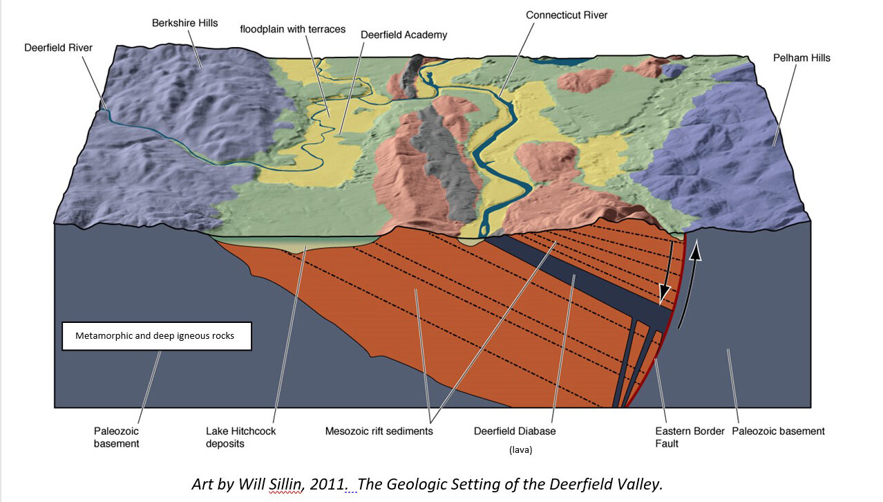
First, let’s solve the wide valley topography of the lower Deerfield. During the Mesozoic Era of geologic time, about 200 million years ago the supercontinent of Pangea began to break apart. Splitting stresses created a long fault zone that reached from Keene, NH to New Haven, CT, and beyond. A “rift valley” was created by these stretching earth movements, and into this valley rivers washed great volumes of sediment — sand, gravel, and mud. These become the “red rock” that underlies Deerfield and is so well exposed at South Deerfield’s Mt. Sugarloaf. These sedimentary rocks are weaker than the hard metamorphic rocks and granite of the upper Deerfield River. Indeed, this sedimentary seam in the western New England bedrock is quite weak and, over time, rivers such as the Connecticut and its Deerfield tributary develop wide valleys here.
Another important consideration is the effects of glacier erosion. The Deerfield Valley has a north-south orientation. The flow direction of the glacier ice is southerly, allowing the ice to move fast and cut deeply along this straight “highway” of weak rock. Under Deerfield, the red bedrock is 150 feet below ground, hidden by glacial till and deposits of Lake Hitchcock.
If you were here 16,000 years ago the glacier ice margin would have been right in Deerfield. It would have looked like Glacier Bay, Alaska (without the really high mountains). Tourist cruise boats could have easily passed over Deerfield’s lake bottom location as they reconnoitered the ice cliff, hoping for a massive iceberg to calve and splash. (Today, calving events can still be heard in Deerfield….at the farm!) Winter would have easily been twice as long as today.
One important mystery of Lake Hitchcock is defining its geography. Where was the shoreline? This is rather easily done by geologists. Deltas, built by rivers into the old lake, are significant flat topped landforms that mark the old lake surface. They can be traced throughout the Hitchcock extent, and in the Deerfield area they mark an elevation about 300 feet above sea level. Eaglebrook School’s location, just uphill to the west, is at the old shoreline. Historic Deerfield is on the old lake floor. It was under 150 feet of icy, muddy Lake Hitchcock water for exactly 1389 years. How can this be dated so precisely? The lake floor is composed of a hundred feet or more of fine grained deposits (clay to silty sand) called varves that can be counted year-by-year, like tree rings. During winter, when the lake surface was frozen, clay settled to the lake bed and when summer finally came, the forces of incoming streams and wind stirring the lake brought silt and sand to cover the previous winter’s clay layer. A drill core on the Amherst campus of UMass sampled 1389 varves, accurately marking the time of Lake Hitchcock in this section of the old lake.
Historic Deerfield’s location is not just “on” the lake bottom, but “in” the lake bottom. The flat Hitchcock floor underlies South Deerfield and Greenfield at an elevation of about 250 feet above sea level. The elevation is 160 feet at Deerfield Academy, and 30 feet lower along the river floodplain. The Historic Deerfield community is almost 100 feet beneath the old lake floor. How could this happen? There is a meandering river a stone’s throw to the west. River erosion is the answer. Meandering rivers cut terraces as they curve back and forth, eroding ever downward. The Deerfield has shaped a classic river landscape here, just like a miniature Mississippi.
How long did this river erosion take? Lake Hitchcock has been gone for 14,000 years and the river could not have flowed over the lake bed until the water was drained, so this is our timeline for creating the Historic Deerfield landscape.
Another major mystery is why the Deerfield River flows to the north, and not in the expected regional slope, to the south, such as the flow of the Connecticut River. The Deerfield and all the scenic terrace development should be along a course through South Deerfield and Whately, entering the Connecticut River near the base of Mt. Sugarloaf.
My approach to most landscape mysteries is to “blame the glacier”. If you consider the wide-ranging effects that a massive cover of ice has on the landscape, certainly some hypotheses for solutions can be posed. In the case of the “misdirected” Deerfield, I think that crustal rebound in early post glacial time may be the answer. Here is the scenario. First, the weight of glacier depresses the Earth’s crust by hundreds of feet. [You’d be depressed, too, if you were covered by several thousand feet of glacier ice for thousands of years!] When the ice melted, the landscape rebounded, but not uniformly. Southerly areas, which had the weight of the ice removed by melting first, rebounded before the more northerly areas. The rebounding landscape, therefore, would have had a slight tilt to the north when Lake Hitchcock drained. This tilt would have angled the Deerfield River to the northerly side of its delta. When the lake drained its flow would have been directed toward the north and it quickly would have cut through the delta sediment, developing its valley in this direction. The Deerfield terraces were created by the erosion and subsequent flood deposits. Each terrace level was a former floodplain at the time of its creation. These levels today form the underpinnings of Deerfield’s interesting stair-step landscape.
There are many stories preserved in rocks and landscapes, and the Deerfield Valley illustrates some magnificent mysteries that excite the imagination. Considering Historic Deerfield: there is perhaps no better place on Earth to sit and contemplate on the scale of human time as well as geologic time.
Richard D. Little, Professor Emeritus, Greenfield Community College, Greenfield, MA. has taught at Deerfield Academy, and done programs at Historic Deerfield for many years. He will be one of the lead geologists at Historic Deerfield’s “The River, Drifting Continents, Dinosaurs, and a Glacial Lake: Understanding the Amazing Stories Preserved in our Rocks and Landscape” July 12 – 16, 2021. He is the author of Dinosaurs, Dunes, and Drifting Continents: the Geology of the Connecticut River Valley, and leads “Fantastic Landscapes” tours to outstanding North American locales. His web site is EarthView.rocks (http://earthview.rocks). For comments and questions he can be reached at rdlittle2000@aol.com