Rarely was Epaphras Hoyt (1765-1850) of Deerfield idle. When not attending to his duties as postmaster, or register of deeds, or county sheriff, or any of his other offices, he appears to have spent every spare moment reading and writing. His journals and notebooks in the Historic Deerfield library, filled with references to books, quotations from newspapers and published works, and his own opinions on a wide array of topics, attest to Hoyt’s intellectual vigor.
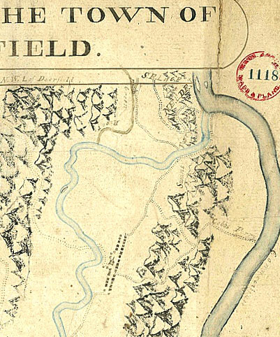
Like his brother, David Hoyt Jr. (1757-1803), Epaphras worked much of his life as a surveyor. In the 1790s he made surveys of new roads for the town of Deerfield, and in 1805 he travelled to eastern Maine to layout out a township granted by the Mass. General Court for the support of Deerfield and Westfield Academies. While Hoyt seemingly shunned leisure, the years 1825 and 1826 were particularly arduous. In addition to his numerous local responsibilities, Hoyt surveyed the route of a proposed turnpike from Charlemont to Adams, Mass., and a canal route from the mouth of the Deerfield River where it joins the Connecticut, westward to the Hoosick River in Vermont’s southern Green Mountains. In “Reconnoisances of Canal Routes, from Connecticut River, to the Hudson,” Hoyt commented on the topography and geology along the rivers. His report, dated Sept. 1825, was published with that of well-known engineer Loammi Baldwin Jr., along with correspondence of Canal Commissioner Gen. Henry Dearborn as Report of the Commissioners of the State of Massachusetts on the Routes of Canals from Boston Harbour to the Connecticut and Hudson Rivers (Boston, 1826). Epaphras Hoyt’s brother, Elihu, also served at that time as a state Canal Commissioner, and may have influenced the choice of surveyor.
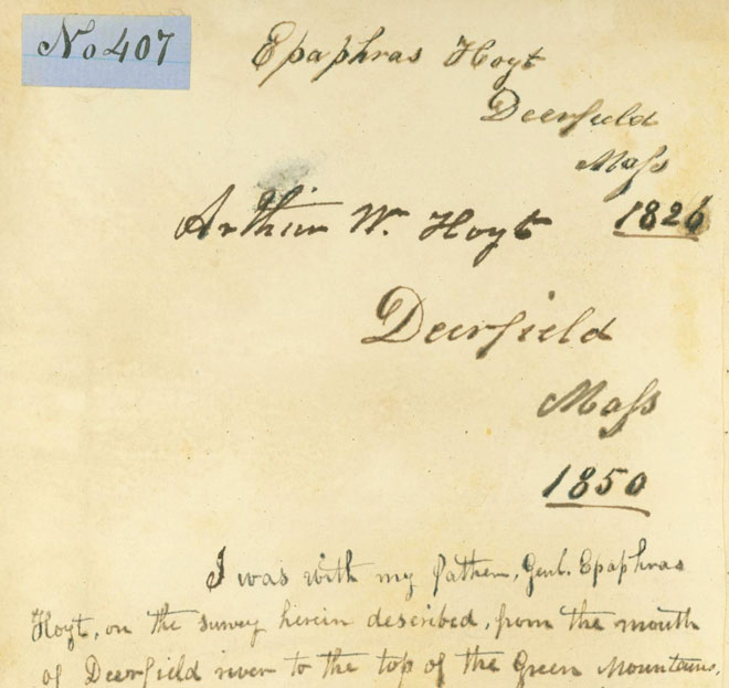
A unique feature of Historic Deerfield’s copy of the Report is that it had been owned by Epaphras Hoyt. Arthur Hoyt (1811-1890), an accomplished surveyor in his own right, inherited the book from his father in 1850 and added his signature to it. Twenty-four years later, Arthur annotated it:
I was with my father, Genl. Epaphras Hoyt, on the survey herein described, from the mouth of Deerfield River to the top of the Green Mountains above the present Tunnel [i.e., Hoosick Tunnel]. I carried the “Target” or “leveling staff” as it was then called, and was the first person who reached the summit of the mountain. We had a delightful time on the entire survey, I being only 13 years of age and out into the world for the first time… How well I remember all, & although I have since been on mountains seven times as high, yet no mountains ever appeared to me as high as did those Green Mts. when first I saw them.
Epaphras Hoyt began work on another state-sponsored survey in July 1826. Since the chartering of the colony of Connecticut in 1662, disputes with Massachusetts over their shared border had been ongoing. To remedy this, a new survey was done in 1695, and another in 1702. Other surveys followed in an attempt to redress competing claims involving Connecticut River Valley towns. The neighboring states agreed to one more survey to settle matters, and Epaphras Hoyt was named as one of the boundary commissioners.
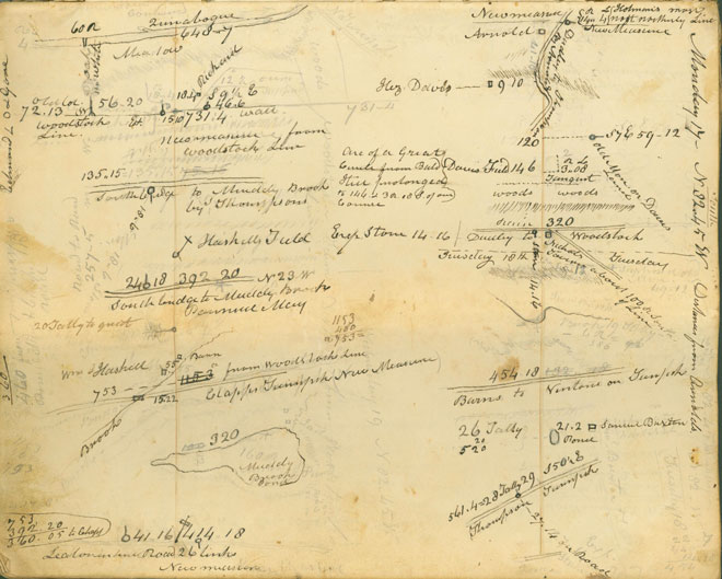
Travelling from Deerfield to Thompson, CT, in the northeast corner of the state, Hoyt joined the two other Massachusetts commissioners and their Connecticut counterparts. His notebook, in the Historic Deerfield Library, provides details of the survey in measurements, sketches, and words. From Hoyt’s journal we learn that Arthur accompanied his father at least part of the time, gaining additional experience that would later serve him well. Epaphras Hoyt’s involvement in the survey covered two non-contiguous periods, and ended on Nov. 6, 1826. The line that he and the others had measured was accepted by the two state legislatures, and today’s boundary, including the so-called Southwick jog extending into Connecticut, became codified.